LOST PLYMOUTH
A talk by Dr. Felicity Goodall
“During the Second World War, Plymouth earned the distinction of being the most bombed city outside of London. But it was the planners, not the Luftwaffe, who caused most damage over the years, and today few traces remain of Plymouth as it was in the days of its most famous son, Sir Francis Drake” In her talk of the same name, Felicity selected a number of snapshots from the city’s busy past..
She said that Plymouth had been shaped by war and the sea as well as sometimes acquiring the sobriquet of the City of Women due to their trading and other less savoury exploits supporting ships crews, the birth here of the suffragette movement in 1869 and the later influence of Nancy Astor, a woman of temperance and the first lady MP to take her seat in the House of Commons.
From the periods of fighting the Spanish in Drake’s time, through the English Civil War, wars with the French and the Crimean War, Plymouth built up a reputation as an ocean port and for building ships and creating its own naval adventurers and heroes – John Hawkins the slave trader, Captain Bligh of the Bounty fame once lived on the Barbican; Tobias Furneaux who navigated around the world was born at Swilly House and Scott of the Antarctic was born at Milehouse.
Huge numbers of soldiers congregated in the city and went to sea despite awful conditions. The city was crowded and unruly – in 150 yards within Castle Street, there were 15 public houses. Crews started being lost to sexually transmitted diseases and in time Plymouth gained a reputation as the VD capital of England, though Chatham and Portsmouth were not far behind. This led to the first Contagious Diseases Act in 1864 where women out after dark could be arrested, even “examined” and locked up in the Royal Albert Hospital.
Felicity related the story of what was said to be Lord Nelson’s favourite ship, the Devonport built “HMS Foudroyant. Launched in 1798 the 80-gun oak ship had the reputation of being the place where his affair had started with Lady Hamilton, but also where he defeated the French in Malta. She served as guard ship for the Naval base until 1862 but was finally pensioned off in 1892. In 1897 she was damaged in a storm off Blackpool, finally being broken up for souvenirs before another storm took her to the bottom of the sea later that year.
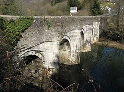
Although Plymouth is much changed, many aspects and landmarks of its past can still be found. Devonport in particular has many relics including old, cobbled streets, fortifications and dockyard walls. The Citadel from the 1660’s and part of the old Plymouth castle walls on the Barbican are still there. In her talk, Felicity showed many fascinating images though but could not possibly fully illustrate the richness of the city’s past and detail what can be discovered by walking around today. Her book however, currently out of print, does a splendid job in bringing this history to life.
12,000 YEARS OF DARTMOOR ARCHAEOLOGY
A talk by Lee Bray
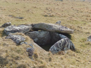
Cist at Crow Tor by Nigel Rendle
Lee stepped in at short notice following the unavailability of the scheduled speaker with a fascinating talk on the rich archaeology that has existed on Dartmoor and much of which is abundant on the ground today. He started with the early years of the arrival of humans in the Mesolithic period, with the climate warming, trees appearing, and the people being hunter gatherers from evidence found of their stone tools.
He described the recent advances in DNA and how this has helped to dispel myths on the physical appearances of the early humans, especially as there seems to have been a steady influx of people from the Middle East and beyond.. Agriculture started coming in from the Early Neolithic with the first farmers growing crops and the use of swaling. By the Late Neolithic c3-2,300BC we see remains of their stone rows and circles.
Following this came the discovery of tin and copper and the alloy bronze. Dwellings in the form of roundhouses or hut circles, ceremonial monuments, burial cairns and kistvaens (cists) from this era are everywhere on the moor today at places such as Merrivale and Lakehead Hill. In recent years the discovery and excavation of such a burial site at Whitehorse Hill has proved to be one of the most amazing in the whole field of archaeology. As well as human remains, thought to be a young woman, the cist contained a cow hair basket with clay and amber beads, turned wood studs used perhaps as nose or ear decoration, and 32 tin studs wrapped in what has been identified as a bear pelt. As the Bronze Age progressed we see the appearance of grazing boundaries, low stone banks known as reaves, often containing the roundhouses mentioned above. Between 800BC and 43AD, we recognise the Iron Age and the arrival of hillforts such as that at Hunters Tor in the Teign Valley.
The post Roman period , known as the Early Medieval up to the Norman Conquest, we see the appearance of fortified burghs and earthworks such as at Lydford. Then the post Norman castles. Climate improvement then saw a movement of people to the uplands and settlements like the outstanding Hound Tor village and evidence of corn harvesting. By the 1300’s though as climate changed again, there were famines and the Black Death, so people were moving back down to the lowlands. Rectangular longhouses and route markers like wayside crosses still remind us of these times.
Industrial archaeology is of course very evident across the moor with almost every river and stream showing the endeavours of the tinners with their miles of leats channelling water to the streamworks, blowing houses and stamping mills. Later this led to more open cast working with wheel pits, dressing floors and buddles for sorting the waste. Quarrying too was a big industry with the plentiful supply of granite, those at Merrivale, Foggintor and Swelltor now fascinating areas for exploration. Even the military have a place with their observation posts, firing ranges and the target railway near Row Tor.
For the future of archaeologists and their studies Lee said there will be plenty to concentrate on like forestry, water supply and management and the impact of more leisure. Plus of course new discoveries from the past…watch this space!
THE TAMAR BAL MAIDENS
A talk by Lynne Mayers
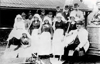
From doing a bit of research to please her mother, Lynne has since immersed herself in miming history, the author of several books, and here tonight related stories of the young women and children who worked in the local mines.
The first real records of these maidens who worked in the “Bals” (Cornish for mines) appear in the 14th century at the Calstock Lead Smelter, the presence of silver and lead around the Bere peninsula and the demands for coinage creating employment, especially for women in washing and sieving the ores. Increased numbers of families came to the area as tin, copper, wolfram, zinc and manganese mines amongst others led to a huge demand for all sorts of skills. Women were employed as tin traders and tin streamers in the Tavistock, Walkhampton and Ashburton mines and in 1792 the Rev’d Swete observed girls “spalling” (breaking) and “cobbing” (sorting) in the copper industry.
By the 19th century improved technology with pumps driven by steam, drove the demand for the maidens with over 500 employed in the 1860’s over 15 parishes. By 1901 this has shrunk to just 5. Lynne described the various processes and the varied tasks which differed depending on the minerals involved. Ages ranged from 6 to 67, the average being between 14-18. Most women left when they got married. There were lots of paupers, some workers with blind parents, daughters of widows and some who were deaf – probably an advantage in an extremely noisy working environment. Working conditions were terrible with low pay, long days and often back breaking work with heavy tools. Health was always an issue with diseases and accidents, although a small sample suggested reasonable life expectancy. The maidens wore long skirts, aprons and covered heads, hands and feet wrapped in rag bandages, sometimes working in bare feet. Untied aprons suggested availability for marriage. Housing conditions gradually improved in the 20th century when the Duke of Bedford provided accommodation in Bere Alston, Wheal Josiah and the Caledonia hostel in Gunnislake.
Lynne went on further to describe the various roles across the industries during the mid-1800’s: 25 were employed at Coryton and Lifton in manganese; dangerous work with arsenic in the calciners; dressing china clay blocks; laundry duties in the count-houses as well as first aid and dealing with corpses. A Jenefer Terrill was the “guardian of the pasties” – a dinner lady, and Sally Satterley of Hexworthy drove horses. A Rebecca Martin in 1861 became a manager and bought Lee Moor clay works for her son.
As the 19th century progressed many mines closed and families moved away to other areas and industries such as coal and even overseas to the US, Mexico and Australia. In the 20th century some did reopen particularly during WW1 and WW2. Clay working is still prominent in Devon and Cornwall though now heavily mechanised and the wolfram (tungsten) mine is operating at Hemerdon.
Lynne ended her fascinating talk with a display of some of the clothes and tools used by the maidens and the statistic that 52% of the current workers in the South Crofty/ Wheal Jane mining project in Cornwall are women. One suspects that the tasks and conditions are a little different from those in the past.
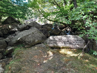
BEARDOWN INSCRIPTIONS VISIT
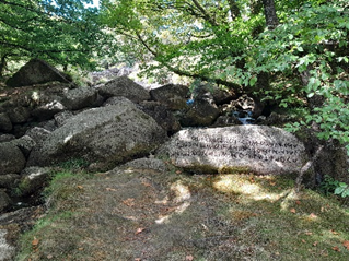
Slippery tree roots, high stiles and rocky terrain did not dampen the enthusiasm for 20 of our members who accompanied Simon Dell on his recent walk through the woods alongside the River Cowsic. Although moss and Mother Nature have since obscured much of the excellent detail rediscovered a year back by Simon and his team, there was still enough to see to complement his earlier talk on the same topic.
Edward Atkins Bray had long been fascinated by the early Greek and Roman poets and the Druids and in the late 18th century embarked on his rock inscriptions project. All 22 of these have now been identified and recoded anew. Although Bray had grand ideas about inscribing short couplets on the boulders, most ended up as 1-word dedications to his favourites. On our walk the first of these were encountered just above and below the 1890’s farm bridge. Among the first 7 we see carvings to Shakespeare, Milton, Burns and Spencer, all just visible under the moss. Above the bridge to Collins and Beattie, the latter with an added to Carlyle, thought to have been added later around 1900.
Further on over the wall we see mentions of Varro and the vertically inscribed Roman Augustus. Entering the field through the gate, taking care not to let the sheep escape, we look at several large rocks before descending into the small woodland. One of the most interesting in the field is to Horace on a rock which has been cleaved, destroying what is thought to have been a couplet underneath., Close by are mentioned Bonarelli, Guarini, Ramsey and Sidney.
In amongst the trees and the nettles are some of the best examples of Bray’s work on huge boulders, all with couplets – Virgil, Tasso and Cicero included. One of my favourites is to Atticus – “Far from the Forum’s noisy strife, thou lovedet (sic) to spend thy rural life”.
We walked back down the track and over the splendid ancient clapper bridge perched above the original stepping stones. On the “Isle of Mona” (not crossed on the night) are 2 stones carved with Celtic runes or the “Sprig” alphabet, now successfully translated On a flat rock close to the path is the inscription “Ye Naiads Venera” – a worship of the river nymphs. A recess or grotto in the rocks here is known as Merlin’s Cave. Further upstream, we hear of another inscription, from Milton’s poem L’Allegro, reading “Sweet posey fair fancy’s child, thy smiles imparadise the wild”.
A detailed article on this topic by Simon will be appearing soon in the “Transactions of the Devonshire Association”
RUMLEIGH HOUSE VISIT
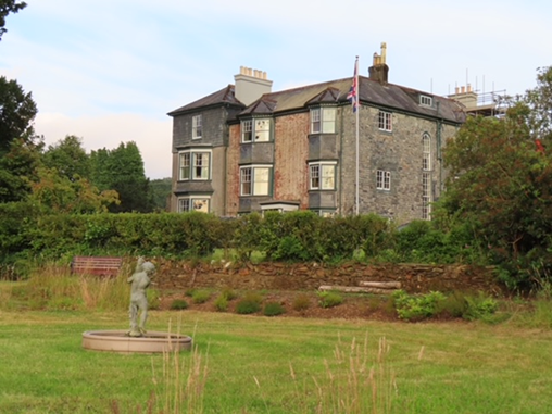
On another beautiful sunny evening, courtesy of the current owners we were shown around the old estate of “Rumley “on the banks of the River Tamar. The Grade 11 listed house had been empty for 5 years and is now undergoing major restoration works. Jonathan explained in detail the history of the 300-acre landscape which is thought to have 14th century origins. Most of the development however has been from the mid 1700’s with major changes and improvements taking place with different owners.
One of the earliest of these was a merchant and Mayor of Plymouth called Thomas Darracott who probably used it as his family’s country retreat and a symbol of prosperity .With income available from the farm he was able to add extensions to what was then a much smaller house. Later, wealthy and influential developers included the Youngs, Franklins and Crofts who tailored the estate for different purposes including market gardening, building huge oil heated greenhouses and stabling for horses. In the early 1800’s the landscape was further developed with new driveways, gardens, woodland and riverside walks. Extra brickwork wings with hanging slates were added to the house to accommodate servants’ quarters and a library. In 1820 it was described as a “genteel mansion” by the poet Carrington.
Huge Monterey pines and other ancient trees now dominate the wooded gardens though remains can still be seen of an old, curved wall and “ha-ha”. We walked down through fields to the old quay on the river, passing an 18th century hollow way, quarry and WW2 bomb craters (it is thought that munitions may have been hidden under the trees). Further along on the edge of the riverbank are the remains of a fascinating stone summerhouse with cobbled floor, probably once used for boat stops and a pleasant spot to entertain and relax. A nearby 1769 lime kiln is indicative of previous industry.
Christopher’s tour of the house interior is hard to describe with around 20 rooms undergoing significant restoration, although adorned by their own period artefacts. The rooms include a reception hall, drawing room, dining room, library, study and telephone room, kitchen, scullery, laundry, stores (once a dairy and apple store) plus old fireplaces, bedrooms and bathrooms. One room once even contained a floor to ceiling bird cage. The south wing has a self-contained holiday cottage.
We concluded our visit in the recently restored walled garden with its beautiful shrubs , flower borders, fruit orchard and ornamental pond, with tea and biscuits served up by our excellent hosts.
Jonathan and Christopher have taken on a massive project, achieving a lot already but with much still to do. So much history is contained within the listed house and grounds and as part of the Tamar Valley National Landscape it is surely worth preserving. Every effort should be made therefore by the various bodies to assist in making this possible.
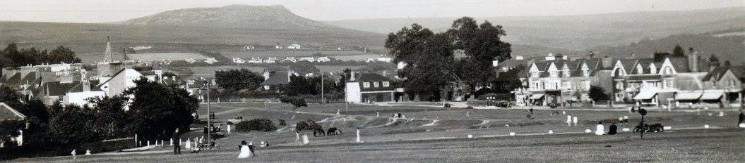
BERE ALSTON – A GUIDED WALK WITH Clive Charlton

Above: Station Road and Ebenezer Chapel 1920 – courtesy of Clive Charlton
On a nice sunny evening, Clive led us around this old historic mining settlement supplementing his talk with many interesting old photographs.
Starting on the old site of Curly Jack’s shop, Clive explained how the original hamlet was founded on a hilltop at the head of a valley. Its name stems from being on a peninsular (Bere) and probably a Saxon chief Althamston, later becoming part of the lands of the de Ferrers family.
It grew in importance in the late 13th century with the discovery of silver and lead which was much in demand for use in the continual wars with our European neighbours. This led to a huge influx of miners and their families from around the world. With the additional growth in the horticultural industry, it was also granted market and borough status.
Clive mentioned the variety of water sources as we passed up Tap Hill pausing to look at an old well. Other notable buildings were the old blacksmiths (Anvil House) and the old post office built of Roborough stone. In Bedford (prev. Gallows) Street stands the oldest house. . He said that despite Chapel Street having an old nickname of St. Giles in the Fields it was probably a slum!
We moved on through Drake’s Park, its curved road design indicative of earlier medieval strip fields. Crossing over Broad Park road (the original direct route through to the river), we paused at the amazing views of Calstock and beyond.
Broad Street, a 20th century development, led us into Station Road, formerly Frog Street and changed with the coming of the railway in 1890. Here is one of the oldest primary schools in Devon. Founded by Sir John Maynard in 1665, the original red doorway still stands with the date carved into the porch.
With the revival of mining again in the 15th century, albeit with new technology, the population increased significantly. There was lots of billeting in Lockeridge Road and the building of several chapels. The Parish hall opened in 1912, financed by the Edgcumbes and their rental incomes. It enjoyed life as an early cinema and was used a lot for supporting WW2 activities.
The village was also notorious for being a “rotten borough.” It was declared in 1580 as a parliamentary constituency and many prominent landowners and gentry folk took advantage to secure their seats in power by dubious means. Cornwall (prev. Pepper) Street housed the burgage holders, the only ones entitled to vote, leading to much local friction and bribery. This all changed with the 1832 Reform Act.
We ended our walk in The Square, a site built for miners and their families and sponsored by metal engineer Percival Johnson. In the 1851 census there were 84 residents living here.
This was a fascinating stroll around this ancient village enhanced greatly by Clive’s extensive knowledge. The area is much changed now from its early origins with a lot of new development and facilities, but its history remains as interesting as ever.
“Fishery Friction: tales of fish related disputes on the Tavy”
A talk by Dr Sharon Gedye
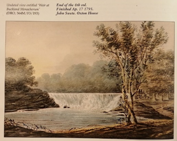
An image of the Buckland Abbot’s Weir copied by permission from Dr Sharon Gedye’s blog entitled “A walk in English Weather”
Sharon started the talk by introducing herself and explained her interest in the Tavy Fisheries as that of their historical importance but lack of appreciation by the region’s heritage.
She first explained the difference between mill and fish weirs and how a fishery operates, in particular the use of weirs to control the movement of fish upstream. Two of these existed on the Tavy called Drake’s and the Abbot’s weirs. Fishery owners extracted the large, trapped fish with boats and nets downstream of the weirs.
Sharon focused on a few key episodes that demonstrated the conflicts and challenges faced by the Tavy fishery:
The fight at the new Buckland Abbot’s fish weir in 1280 between Thomas Gyrebrand, the forester to the Abbot of Tavistock, and a number of Buckland men who were chopping trees down in Blackmoorham wood which was near the weir. Thomas was shot by an arrow made of ash and headed with iron and steel and none of the Buckland men saw who shot him. Thomas was gaoled for bringing a false claim of robbery and ordered to pay ½ a mark. Two of the Buckland men were ordered to pay 1 mark each. The jury decided that the men were in the right to take wood from the Tavistock side of the river.
Thomas Drake v William Crymes 1601: this was caused by the post dissolution havoc whereby estates were broken up with different owners. The lease of the fishery to Drake in 1592 included permission to build a weir and a corn mill. William Crymes owned the manor of Buckland and threatened to dismantle the weir so that he could build his own as he was claiming the fishery belonged to him. Drake petitioned Lord Mountjoy to intervene. This dispute involved many legal and physical confrontations over fishing rights and weir ownership over a long period of time.
A dispute between Buckland Abbey and Maristow 1690s to 1750s: Sir Andrew Slanning claimed rights to the fishery leading to long conflicts and poaching incidents. In 1706, Nicholas Bailey and some other men said they had witnessed an incident of poaching some years previously by servants from the Maristow estate who were fishing in Old Wood and had arrived in a boat. They were asked to come ashore and some did but they all ran away except one, Will the Potter. Nicholas Bailey said he took the net and rope away but Will kept them away from the boat with a long pole.
The demise of the weirs: the destruction of the weirs in the 1860s increased pollution in the river from mining activities. This caused the fish to sicken and die and finally led to the formation of the River Tavy Fishing Association.
In conclusion, Sharon emphasised the historical significance of the Tavy fishery and associated weirs but noted that it remains a poorly understood but crucial aspect of the region’s heritage.
The Industrial Archaeology of the Upper Plym – a talk by Ernie Hoblyn
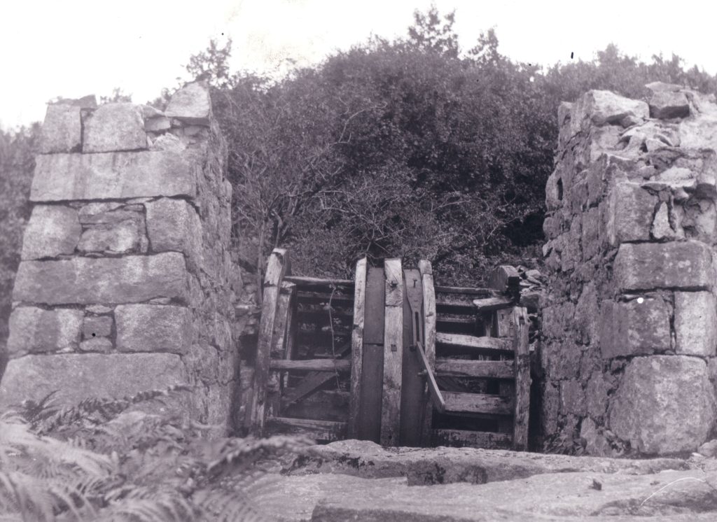
Dewerstone Winding house and wheel 1912 (courtesy of Ernie Hoblyn)
A talk by Ernie Hoblyn
Ernie related how walking his dog and wanting to find out more about what he was seeing, inspired him to research and write a book about the Plym Valley. For our talk, he concentrated on the upper valley from Shaugh Prior.
He first described the old railways of the Plymouth & Dartmoor Tramway (1823-1916) and the subsequent Tavistock & South Devon (1859-1962). Granite was brought off the moor to Plymouth via Cann Quarry and Crabtree; in the early years horse drawn on the P&DRT, later replaced by steam. The old incline plane to Lee Moor can still be seen, along with remains of workers’ huts and stables at Plymbridge. China Clay was also transported by rail until 1939, when it was replaced by piped slurry.
On Roborough Down from the Yelverton Golf course down to the River Meavy at Clearbrook, can still be seen remains of Yeolands Tin Mine, a deep mining venture from 1848. The old mine captains house is occupied and seen nearby are ruins of buildings, an adit which still supplies clean water to nearby houses and various old shafts, some of which have recently opened up through collapses. Copper had also been discovered during the building of the Leighbeer railway tunnel. Another local mine was the Bickleigh Phoenix and like many of its kind produced many false promises of wealth!
The Shaugh Bridge area is particularly interesting with remains of various industries. Three granite quarries existed here owned by the Johnson Brothers. A railway system connected the different levels. Ernie produced a wonderful image from 1912 of the old winding house and wheel used to take the trucks up and down the incline plane (last used in 1868). Remains of an abandoned scheme to connect the quarries to the main railway can still be seen in the form of a bridge to cross the river – never finished. The old counting house and smithy has had various uses since the quarries closed, being a tearoom in 1910. Nowadays, it is known as Dewerstone Cottage, owned by Young Spirit, offering outdoor adventures from river scrambling to rock climbing, with a bunkhouse and campsite.
Down by the river is an old iron mine with two shafts still visible. Quite successful in the 1870’s , ore was carried across the river by horses up to Plymbridge Halt. The ore was also used for brickmaking, the old tunnel kiln with its intricate system of sliding doors still in situ. The Ferro Ceramic Company was wound up in 1873. In the National Trust car park are the remains of the china clay kilns and loadings bays – the clay being formed into blocks and thrown out onto trucks – still in use in the 1096’s. More of Ernie’s images showed how the blocks were stored to dry and an old cottage at the end of the row.
Still so much to be seen today of all these varied industries and a fascinating talk that was enriched by some beautiful old photos from their heydays.
The Civil War in the Tamar Valley 1642-51
A talk by Paul Reid
New Bridge, Gunnislake
Paul surprised us all by turning up in full period costume and with an array of 17th century weapons and artefacts on display. He started by explaining the differences in dress of the opposing forces of Parliamentarians and Royalists, completing a partial strip tease as he further explained how they both wore several layers of clothing which were interchangeable and adaptable to the cold conditions of the time.
Divine right, religion, revolution and republican ideals were all put down as reasons for the war. There was general distrust of the King who supported religious tolerance and favoured the local gentry, whilst Parliament wanted more power and working men’s rights. Devon was Parliamentarian but Cornwall was loyal to King Charles 1 and the Royalist cause. Thus, the River Tamar became an important battleground, Cornwall having some of the advantages of the monies from tin, secure harbours and ports for privateers..
In 1643 Parliamentarians led by the Earl of Stamford clashed with Sir Richard Grenville’s troops at the two river crossings of New Bridge (Gunnislake) and Horsebridge. The Royalists held their ground but suffered more losses through injuries inflicted by pikes, pistols, muskets and cannons. However, some over confidence from the men of Devon led to the Royalists taking advantage of hidden cannons to hit back forcing their opponents to retreat to Saltash.
Meanwhile, a Parliamentarian force led by James Chudleigh had landed at Falmouth and with fresh troops attempted to capture Launceston in a major battle at Polson Bridge. Once again though the Royalists held out forcing another retreat to Devon. There were further skirmishes though both sides retired to regroup and rebuild their forces as things quietened down.
By early 1644 with Royalists still in control of the Southwest, the Earl of Essex was leading a new army heading west and relieving the sieges of Lyme and Plymouth. At the same time, King Charles was also heading west to Exeter where his wife had given birth to Princess Henrietta and whose safety was at risk. Combining forces with Prince Maurice, the King passed through Tavistock and after further skirmishes at the Tamar crossings forced Essex’s army to retreat to Lostwithiel.
At the end of two weeks of fighting, the Parliamentarians were eventually defeated – Essex had escaped and the left in-charge Philip Skippon surrendered and accepted terms. Over six thousand prisoners were taken and marched to Southampton, many dying en route. The battle was the biggest defeat for the Parliamentarians and whilst securing the Southwest increased the popularity of the King for a while.
With peace again established there was a period of rebuilding. Bridges and walls were repaired and Royalist estates sequestered, However, there was local conflict on both sides over increased taxes, there were bad harvests and a fall in tin prices and general unrest, with major changes to come in 1645.
The Building of the Plymouth, Devonport & SW Junction Railway
A talk by Stephen Fryer
Stephen started by explaining the complicated set up of the various rival railways and the competition in providing lines into Plymouth – and beyond. With the broad gauge of the GWR already well established, they were against allowing the standard gauge to become the norm. However, with the Army and Navy expressing doubts about “ensuring the security of the district†the LSWR were finally able to put forward a proposal for a new line in standard gauge from Devonport to Lydford in 1882. Contracts were approved for £790K and work started in March 1887.
Over two thousand navvies were employed on the project and Stephen’s image of a typical gang embraced the times. All dressed in waistcoats but with a strict hierarchy: the boss with his top hat, the foreman sitting down at the front, they were a very hardworking bunch. Often living on site and “hot bunking,†with their wives cooking meals, they also had to buy their own tools and candles. Tavistock Hospital had just opened and many Navvies were treated there.
Via nostalgic images of then and now, Stephen took us along the 22-mile route from Devonport station with its footbridge – now the site of a Technical College, tunnels under Devonport Park and Ford, where the line passed under the main GWR line (only 4 feet above)! A sea of housing has now obliterated all trace of the old limestone and concrete viaduct which was dismantled in the 1980s with the limestone being used in the construction of the Plymouth Dome. At Ford Station, there is one of the first poured concrete bridges in the UK, now buried, along with the station, under spoil from building of the A38 Parkway. A small halt at Camel’s Head was used by dockyard workers, and at St Budeaux, the station even had its own covered walkway approach down to the platforms.
From here, the line still exists, picking up the GWR Tamar Valley tourist line to Bere Alston and Calstock. It passes over the stunning Tamerton Creek and Tavy viaducts, the columns all made from cast iron sections, sunk to the riverbed and then filled with concrete. Further on, another bridge disappeared after a disagreement over maintenance between local farmers. It continues past the picturesque station of Bere Ferrers and then Bere Alston, once very busy from the valley horticulture and flower trade and from where the tourist line branches to Calstock.
From the latter, remains of the line to Tavistock are dominated by the Shillamill tunnel and viaduct, although many of the original features of the route are now obscured by dense vegetation. Another viaduct towers over the town into the old station though the former footbridge is now on the Plym Valley line at March Mills. Heading out into the countryside, the route passed through Wringworthy, Mary Tavy and Brentor – the old station here now carefully looked after in private hands. At Lydford, the GWR and LSR lines are merely yards apart. Old wartime sidings are lost in the undergrowth. The line was built with 3 tunnels, 7 viaducts, and 76 bridges, but by 1968 was closed, along with the ongoing route to Okehampton.
A talk of fond memories enhanced by Stephen’s thorough knowledge, plus input from the incomparable Bernard Mills and their stunning images of the infrastructure and the old engines. Perhaps current discussions about restoring the link from Tavistock to Bere Alston may bring some of these back – without the steam of course.
The Beardown Inscriptions
A talk by Simon Dell
The Bardic stones, courtesy of Simon Dell
Edward Atkins Bray was born at the Abbey House (now the Bedford Hotel) in Tavistock in 1778. His father, a solicitor and steward of the Bedford Estate, had bought Beardown farm and it was here that Edward spent his summers beside the Cowsic river, developing an interest in poetry. Simon’s entertaining talk went on to explain how one man’s dream came to fruition.
On the wishes of his father Edward started training as a lawyer in London, subsequently qualifying and working on the circuit. However, realising he preferred a quieter vocation he turned to the Church. When the Vicar of Tavistock died, he took over the role in 1812 moving into the new vicarage in 1819. Four years later, he married Eliza Stothard whose husband had been killed in a fall at Bere Ferrers church. She went on to become Tavistock’s most prolific author.
Bray was clearly a great lover of nature, the connections with the spiritual worlds and the role that poetry played in bringing these together. One of his carvings illustrate this -â€Sweet poesy, fair fancy’s child: thy smiles imparadise the wildâ€â€¦He became obsessed by the Greek and Roman poets, the Druids, Merlin the magician, the Isle of Mona (aka Anglesey, an old haunt of Merlin’s). Also, a visit to the British Museum to see the Rosetta Stone, perhaps inspired him to create his own vision.
Thus, over a period of about 5 years, in the little wooded valley of the Cowsic, Edward had inscriptions carved on the rocks about his favourite poets. Some of these are in couplets though lack of space and suitable rocks meant most of these were just dedications. Although many were hidden under dense undergrowth for many years, Simon and his team have now uncovered 28 of these. Two are inscribed in Bardic runes – the Celtic “Sprig†alphabet – and have been translated. His Isle of Mona sits in the middle of the river and nearby is the grotto of Merlin’s cave. On one stone the writing is upside down, probably due to the rock having been moved in a flood.
Through Eliza’s famous notes and letters and her correspondence with the Lake poet Robert Southey, many of Edward’s more detailed intended inscriptions have been discovered. For instance, on one of the stones in Merlin’s Cave – “these mystic letters would you know – take Merlin’s wand that lies below.†There would be a white wand with Celtic letters alongside one in the Roman alphabet. Held together would have enabled translation. (Incidentally, Simon produced his own version!).
Edward died in 1857 after 45 years as the Vicar of Tavistock and is buried beneath the cloister arch at St. Eustachius church. In the rock inscriptions he has fulfilled his dreams and left a legacy of his love of Dartmoor and the natural and spiritual world.
Simon will be leading our members on a visit to these special places in August.